Mot de passe perdu ?
Nouvel utilisateur ? Créer un compte
Appréciez et contribuez !
| Trouvez les meilleur spots |
|
|
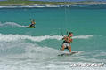
 Anguilla
Amérique centrale
Trade Wind. East in summer and North East in Winter.
Localisation: Caribbean, islands between the Caribbean Sea and North Atlantic Ocean, east of Puerto Rico
Coordonnées géographiques: 18° 15' N, 63° 10' W
Côte: 61 km km
Climat: tropical; moderated by northeast trade winds
Relief: flat and low-lying island of coral and limestone
Sommets: lowest point: Caribbean Sea 0 m
highest point: Crocus Hill 65 m
Risques naturels: frequent hurricanes and other tropical storms (July to October)
Monnaie: East Caribbean dollar (XCD)
Population: 13,677 (July 2007 est.)
Langues: English (official)
Capitale: The Valley
Découpage administratif: none (overseas territory of the UK)
Plus d'informations
| Jan | Feb | Mar | Apr | May | Jun | Jul | Aug | Sep | Oct | Nov | Dec | |
|---|---|---|---|---|---|---|---|---|---|---|---|---|
| Climate | ||||||||||||
| Air temp. | ||||||||||||
| Water temp. | ||||||||||||
| Wind consistancy | ||||||||||||
| Wind force | ||||||||||||
| Best season | ||||||||||||
Vous voulez ajouter des informations sur Anguilla? Dites-le nous...
Cette carte est interactive ! Utilisez les boutons pour zoomer ou vous déplacer.
- Favoris
-
Vos sites favoris et futures listes de spots
Spots
 Commentaires
Erreurs, Réactions
Si vous voulez ajouter de nouvelles informations ou si vous avez trouvé des erreurs sur cette page, Dite-le nous.
De thierry dehove , 13-12-2008
- Anguilla has 30 beaches and amazing kitesurfing spots. I ridded most of the time between Cove Bay and Savannah with East wind.. somtimes in Meads Bay and Long bay with North wind.