Mot de passe perdu ?
Nouvel utilisateur ? Créer un compte
Appréciez et contribuez !
| Trouvez les meilleur spots |
|
|
 Peru
Peru
Amérique du sud
Localisation: Western South America, bordering the South Pacific Ocean, between Chile and Ecuador!
Coordonnées géographiques: 10° 0' S, 76° 0' W
Côte: 2,414 km km
Climat: varies from tropical in east to dry desert in west; temperate to frigid in Andes
Relief: western coastal plain (costa), high and rugged Andes in center (sierra), eastern lowland jungle of Amazon Basin (selva)
Sommets:
Risques naturels: earthquakes, tsunamis, flooding, landslides, mild volcanic activity. deforestation (some the result of illegal logging); overgrazing of the slopes of the costa and sierra leading to soil erosion; desertification; air pollution in Lima; pollution of rivers and coastal waters from municipal and mining wastes
Monnaie: nuevo sol (PEN)
Population:
Langues: Spanish (official), Quechua (official), Aymara, and a large number of minor Amazonian languages
Capitale:
Découpage administratif:
Vous voulez ajouter des informations sur Peru? Dites-le nous...
Cette carte est interactive ! Utilisez les boutons pour zoomer ou vous déplacer.
- Favoris
-
Vos sites favoris et futures listes de spots
Spots
| Spots (4) | Qualité | Expérience | Type | Facilités | ||
|---|---|---|---|---|---|---|
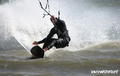
| Lobitos | - / - | Experts | Plage | 

|
||
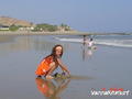
| Mancora | 3 / - | Tout le monde | Plage |


|
||
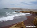
| Paracas | 3 / - | Tout le monde | Estuaire |


|
||
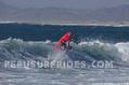
| Puerto Morin | 3 / - | Tout le monde | Plage |
|
 Commentaires
Erreurs, Réactions
Si vous voulez ajouter de nouvelles informations ou si vous avez trouvé des erreurs sur cette page, Dite-le nous.